IDIA Lab virtual celestial simulator and 3D interpretation of the Meridian of August in ancient Rome. Project commissioned by the Virtual World Heritage Laboratory at Indiana University, directed by Bernard Frischer.
Findings presented at the Vatican’s Pontifical Academy of Archeology in Rome
Thursday December 19th, 2013
A Digital Simulation of the Northern Campus Martius in the Age of Augustus. Preliminary Results of New Studies of the Relationship of the Obelisk, Meridian, and Ara Pacis of Augustus
by
Bernard Frischer, Department of Informatics, Indiana University
John Fillwalk, Director, Institute for Digital Intermedia Arts, Ball State University
http://www.pont-ara.org/index.php?module=crpCalendar&func=display&eventid=54
Pontifical Academy of Archeology
http://en.wikipedia.org/wiki/Pontifical_Academy_of_Archaeology
Consultants:
Horology consultant: Paolo Alberi Auber, Italy
Archeoastronomy consultant: Prof. Robert Hannah, University of Walkato, New Zealand
Archeoastronomy consultant: David Dearborn, Lawrence Livermore National Laboratory, U
SA
Data courtesy of NASA Jet Propulsion Laboratory Solar Dynamics Group: Horizons System
A Digital Simulation of the Northern Campus Martius in the Age of Augustus. Preliminary Results of New Studies of the Relationship of the Obelisk, Meridian, and Ara Pacis of Augustus
Bernard Frischer, Department of Informatics, Indiana University
John Fillwalk, Director, Institute for Digital Intermedia Arts, Ball State University
- With generous support from the National Science Foundation (grant # IIS-1014956), we have recently been developing a digital simulation of the northern Campus Martius in the period 9 BCE to 40 CE. [1] Our motivation is to create a tool that makes it possible instantly to see the correct positions of the sun and its shadow at any time of day in this period of time so that the various controversies associated with the work of Edmund Buchner on the so-called “Horologium Augusti” can be approached in a new way. We have two main goals in creating the simulation. First, we want to see if Buchner’s and other scholars’ claims and interpretations about the relationship of the Augustan obelisk, the (hypothesized) horologium (which we now call the Meridian of Augustus, following the lead of Albèri Auber 2011-12), and the Ara Pacis can be verified or refuted. Secondly, we want to use the simulation as a support for an empirical survey all over the area of interest to see if it might even be possible, by broadening the field of inquiry in terms of time and space, to arrive at any new insights and discoveries. We are grateful for the opportunity to report on our findings here, and we begin by noting that these are preliminary and can be expected to be revised as our simulation is subjected to further testing and refinement. We concentrate here on the first goal of verification and refutation, reserving a report on the second goal to future publications.
- We begin by observing that the use of digital simulations such as ours may still be novel in the field of Roman topography, but they have been used since the early 1950s in physics (Galison 1997:759) and then, increasingly, in other branches of physical and life science to model systems behavior, to speed up difficult computations, and reduce the opportunity for human error. The grounds for and limits of their validity have been usefully treated by Humphreys 2004; and their potential utility in archaeology was mooted by Frischer 2008. As Humphreys stated, “the enormous flexibility and precision of simulation methods provide an opportunity to implement Gedankenexperimente in contexts providing much greater precision than is possible with traditional mental implementations, and they are free from the psychological biases that can effect even simple thought experiments” (Humphreys 2004:115-116).
- Of course, precision and valid results always depend on the reliability of the data represented in a simulation. For the all-important apparent size[2] and position of the sun in the sky dome of the simulation, we have relied on NASA’s Horizons System (http://science1.nasa.gov/planetary-science/planetary-science-data/horizons-system/). Among other things, this database takes into account the changes in the sun’s apparent course through the sky that arise from the earth’s wobble as it rotates, providing correct azimuthal information for any point on earth in any historical period, including the Augustan age.
We take as our point of departure the archaeological data and interpretation of the site given by Albèri Auber in this volume and in other publications, especially Albèri Auber 2011-12. We agree with him in the following essential points.
(a) The obelisk was used as the gnomon only for a meridian, not an horologium inscribed on a large pavement, for which no evidence has ever been found. Its purpose was scientific: as Albèri Auber 2012: 484-489 shows, it helped insure that tracking of leap years was correctly done through the observatio umbrarum (Pliny NH 2.35)
(b) There is only one phase for the obelisk-meridian: the Augustan phase. Buchner’s Flavian phase is a phantom based first on his reliance on Guarducci’s dating of the letters of the inscriptions found at 48 via Campo di Marzio to the first century CE (Buchner 1980: 362), a dating later withdrawn without comment (Buchner 1983: 505); and then on the brief report in Rakob 1987: 693- 94 that La Torre dated the ceramic fragments found in Buchner’s excavation to the Flavian period. However, La Torre has never published the pottery, nor did Rakob ever publish the stratigraphy, quota levels, and a plan showing the exact find spots. Until this evidence is produced and interpreted, we must suspend judgment. Our consultant on Greek epigraphy, Mika Kajava, will be writing a report on the dating of the lettering. Here we may quote his personal communication of August 1, 2013: “Considering the meridian inscriptions, in my view, it would be difficult to suggest a precise dating on the basis of paleography: an Augustan monumental text set up in a public place could look very similar to a Claudian or even a Flavian one. This is also because monumental writing tends to be conservative, and occasionally it is even archaizing. In the present case, one may also wonder if the fact that the texts were presumably modelled upon Greek precedents had some (extra) influence on the letter style.”
(c) The sub-phases of the project are: (i) the idea to bring an Egyptian obelisk to Rome as a manubial donation: presumably in 30 BCE after Augustus’ victory over at Alexandria and his annexation of Egypt; (ii) the vow of the Ara Pacis on July 4, 13 BCE; (iii) the dedication of the obelisk in 10 BCE,[3] presumably in conjunction with the twentieth anniversary of the victory at Alexandria;[4] (iv) the dedication of the Ara Pacis on January 30, 9 BCE; (v) the addition of the meridian at an indeterminate date during the reign of Augustus.[5]
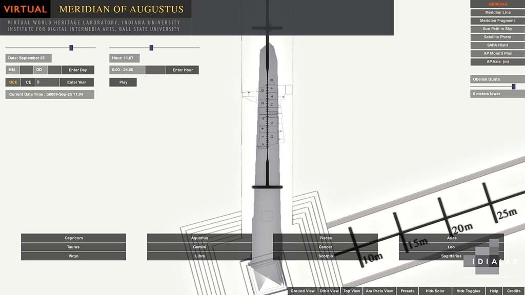
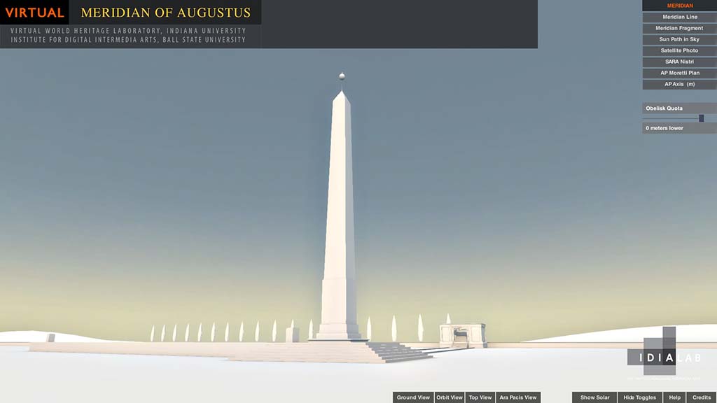
(d) The height of the obelisk (including plinth, the bar between the pyramidion and the sphere, and the sphere itself) was 100 Roman feet. Haselberger (personal communication, October, 2013) stresses that this dimension is based on evidence that permits a range of possible heights varying by 3 to 6 feet depending on such factors as how we convert the Roman foot to meters, the unknown dimensions of the distanziatori (in the unlikely event such actually existed[6]), the height of the pole attaching the sphere to the pyramidion, and the diameter of the sphere itself. Albèri Auber takes a different tack: as a practicing gnomonologist himself, he stresses the practical advantages to his ancient Roman counterpart of working with the round number of 100 Roman feet and the useless complications that result if the height differed fractionally from it. Alberi Auber thinks that if 100 Roman feet is within Haselberger’s possible range of heights (and it is), and if the alternatives force us to work with dimensions such as (to make up some random examples) 101.33 or 103.75 Roman feet which would greatly complicate the ancient gnomonologist’s calculations of the length and subdivision into 360 degrees of the meridian, then, faute de mieux, 100 Roman feet is the obvious solution.[7] We agree.
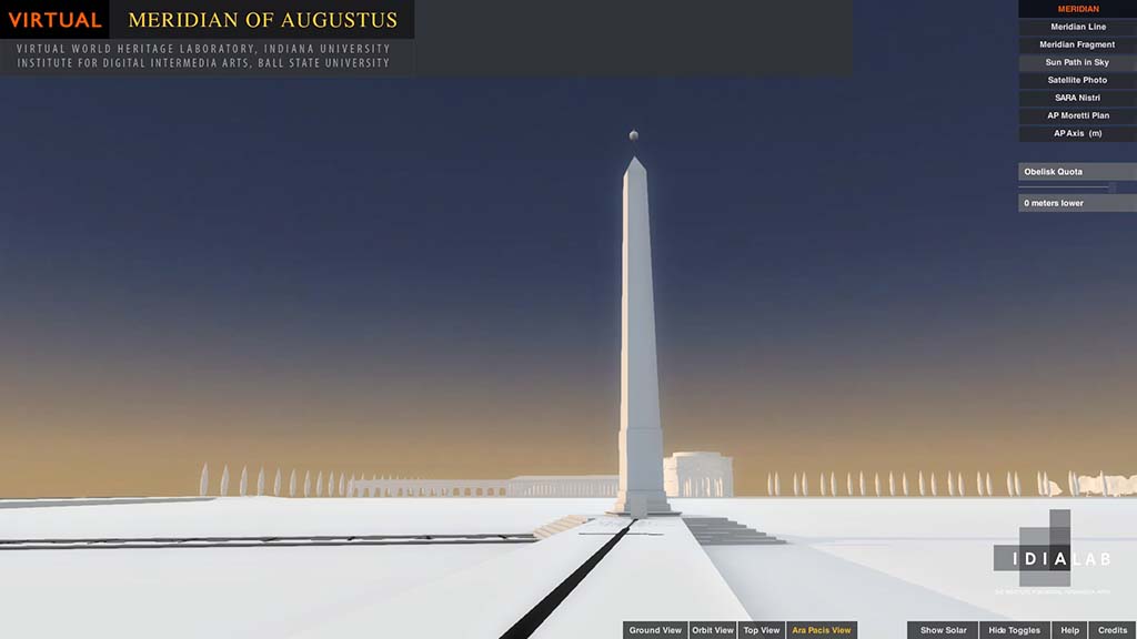
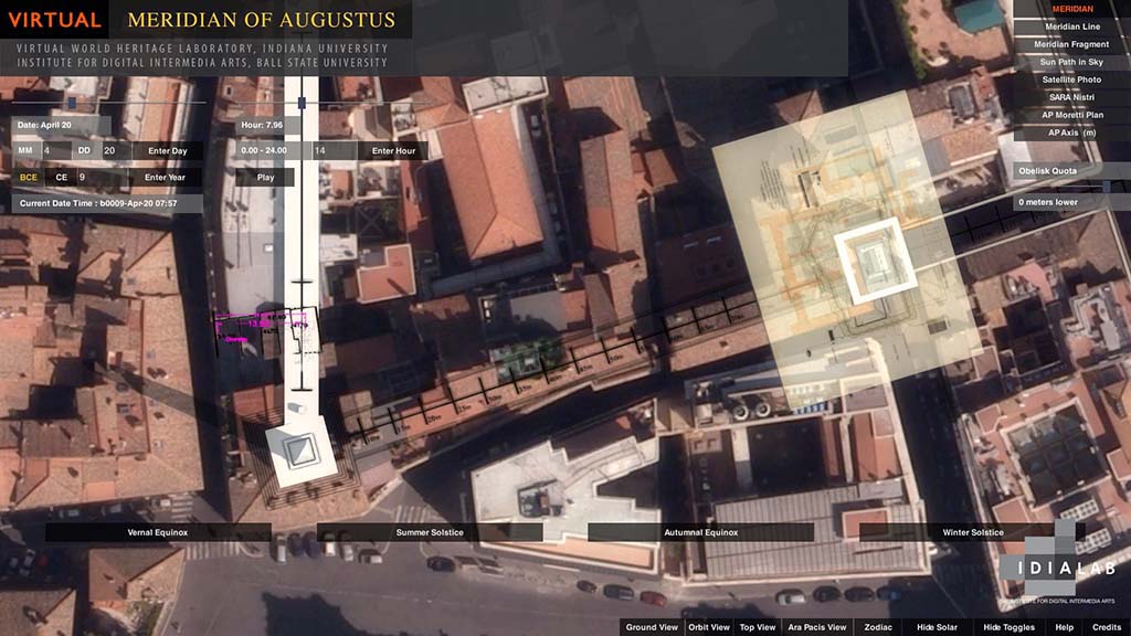
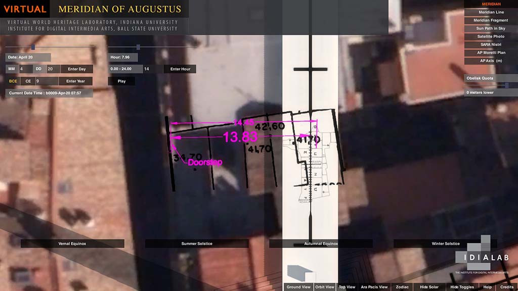
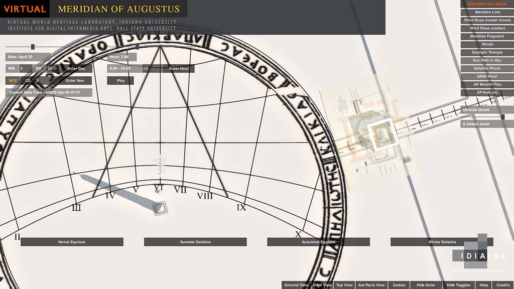
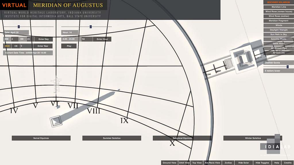
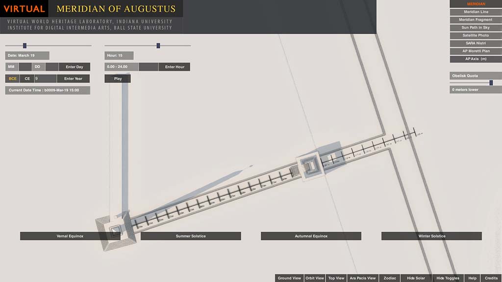
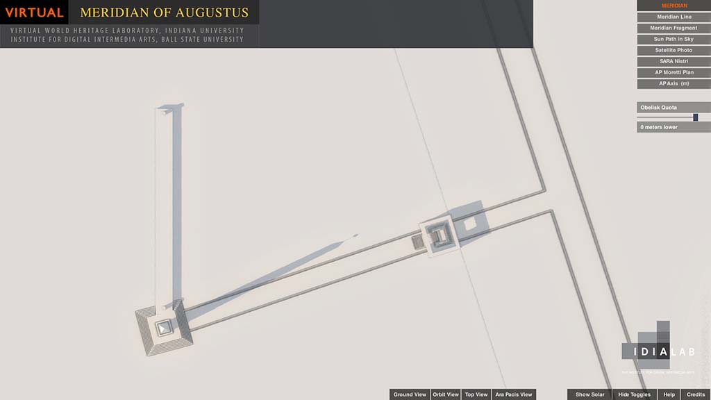
In a forthcoming publication, we give the GPS coordinates, dimensions, and bibliographical sources for our 3D models of the meridian, obelisk, and Ara Pacis (Frischer and Fillwalk 2013). In brief, we claim +/- 2 meter accuracy for the placement of the existing fragment of the meridian at via di Campo Marzio 48 and of the Ara Pacis. The position of the obelisk at piazza del Parlamento 3 was derived from its height and the shadow it cast in relation to the position of meridian fragment, as previous scholars have noted can be done (e.g., Heslin 2007:13). In the same publication, we also describe the technical specifications of the simulation. In brief, we authored the model in Maya and converted the 3D model of the northern Campus to the game engine Unity. We developed a plug-in which, as noted, utilizes azimuthal data from NASA’s Horizons System. In calculating where to position the sun and create a lighting solution for observations concerning the obelisk and its shadow, we used the geocoordinates of the obelisk; for those concerning the Ara Pacis, we used the geocoordinates of the Ara Pacis. Unity makes it possible to roam around the simulated landscape and to see the monuments from both freely chosen and preset points of view. For example when the “Ara Pacis View” is selected, movement is restricted to the hypothetical axial line from the center of the base of the obelisk to the Ara Pacis and beyond to the via Flaminia. The height of the camera is fixed at 1.58 m, the average height of the human eyes. In this way, in Ara Pacis View, it is not possible to deviate from a true axial position, and the sun (or its shadow) appears in a way that would have been visible to the ancient adult Roman.
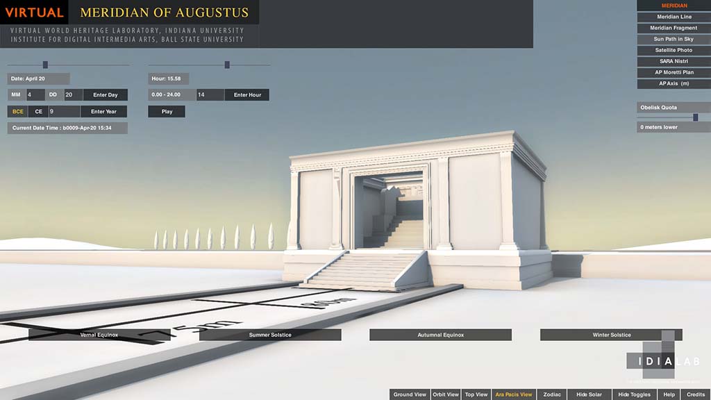
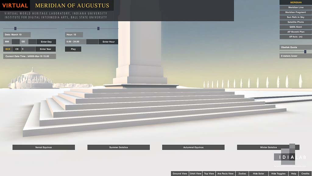
- Everything stated in section 3 explains the default settings for our simulation. But we have made an effort to build a certain flexibility into the simulation so that it can support different interpretations of the archaeological situation. Thus, even though the default setting does not display Buchner’s hypothesized pavement and horologium, we have included a software switch that can be thrown to illustrate where Buchner thinks this would have been positioned. Similarly, we have a slider that can lower the height of the obelisk in units of 1 mm to a depth of 2 meters. Pending additional funding, we plan to make all major components of the simulation equally flexible, so that, for example, one can also raise the obelisk up to 2 meters higher in increments of 1 mm; and one can move the center of the Ara Pacis in any direction by 2 meters in the same increments. In this way, we hope to create a flexible tool that supports assumption-free scientific research, allows adjustments to be made to improve accuracy, and is not limited to one particular reading of the archaeological record. In our view, the simulation ought ideally to serve the needs of archaeologists without itself becoming a new topic of debate.
- On the basis of the default values, we have thus far addressed the following issues that bulked large in the articles published in JRA 2011: (1) Did the shadow of the obelisk travel all the way down the equinoctial line (whether real and inscribed, or purely hypothetical) to the center of the western façade of the Ara Pacis on September 23, Augustus’ birthday? (2) If the shadow hits the façade of the Ara Pacis, does it have salience? (3) Did the shadow of the obelisk point toward the Ara Pacis at some point every day of the year? (4) Is the Ara Pacis oriented, not toward the obelisk, but toward the rising sun on April 21 (Parilia)?
- Before answering the first question, we note that our formulation of it reflects the “strong” reading of Buchner’s thesis about the relationship between the obelisk and Ara Pacis.[8] Like several scholars before him, Haselberger 2011:64 interpreted Buchner to mean only that the shadow progressed along the line, implicitly pointing toward the center of the western façade of the Ara Pacis, but did not necessarily reach the façade.[9] We call this the “weak” interpretation of Buchner. Our simulation can address both interpretations. Here we note that we dispute the weak interpretation and think Buchner did indicate that the shadow hit the façade. Even if Buchner never states this expressis verbis—just as he never says expressis verbis what scholars holding to the weak interpretation think that he says–what Buchner did write, taken in relation to his illustrations, leaves little doubt about what he meant. Buchner 1976: 347 does state, as Haselbeger relates, “am Geburtstag des Kaisers…wandert der Schatten von Morgen bis Abend etwa 150 m weit die schnur-gerade Aequinoktienline entlang genau zur Mitte der Ara Pacis….” The weak interpretation of these words is that Buchner knew that the shadow moved along the equinoctial line but did not reach the facade of the Ara Pacis; and therefore that Buchner’s phrase, “etwa 150 m,” referred simply to the inscribed equinoctial line on the (hypothesized) pavement of his horologium. Our view is that the scholars who think Buchner meant that the shadow hit the façade of the Ara Pacis are right because of the phrase “etwa 150 m.” What does this refer to? If one measures the equinoctial line of the horologium on Buchner’s figure 7 (p. 337), one finds[10] that 1 cm=20 m. One also finds that the length of the equinoctial line on the horologium (i.e., the solid line) is 7 cm=140 m. But Buchner said “etwa 150 m.” If one then measures his dotted line extending the solid equinoctial line to the middle of the facade of the Ara Pacis, one discovers the missing 10 m. For the weak interpretation to be right, Buchner would have to have written “etwa 140 m.” Moreover, advocates of the weak interpretation must also explain why Buchner accounts at p. 346 for a supposed architectural anomaly of the two entrances of the Ara Pacis by claiming that “die Aequinoktienlinie des Solarium geht durch die Ara hindurch, durchschneidet wie di Vorder- so auch die Rückfront….” And this, too, is clearly seen in his fig. 7 on p. 337. This latter point is, it seems to us, decisive evidence in favor of the strong interpretation. Buchner cannot simply mean that an imaginary equinoctial line can be extended from the end of the actual inscribed line through the west to the east entrance of the Ara Pacis. Such an imagined extension of a line would not require a physical entrance and exit point. Buchner must, rather, be loosely describing an actual physical event, namely the progress of the shadow along the (imagined) extension of the equinoctial line through the altar. Clearly it is the shadow that requires the two entrances, not the hypothetically extended line. At any rate, since the weak interpretation is often encountered in the scholarly literature,[11] we address it here as well as the strong interpretation.
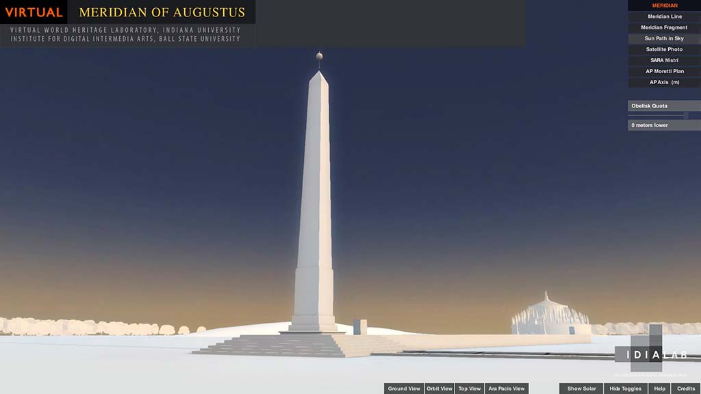
- To answer the first question as understood by the strong interpretation, the simulation suggests that it is true, as Buchner always claimed, that on September 23 the shadow of the obelisk progresses more or less down the (in our view hypothetical) equinoctial line in the zone that would be paved and inscribed with the horologium Buchner imagines. Since September 23 is not the actual date of the fall equinox in the Augustan age (which fell on the 25th of the month on the Julian calendar), the shadow actually fails to hit the line at the beginning of the second hour of the day; but for most of the second hour and all the other hours indicated on Buchner’s diagram of the horologium, the shadow does move along the line. However, the simulation also shows that, just at the crucial moment, when the shadow leaves that zone and approaches to ca. five meters of the center of the façade of the Ara Pacis, it veers off course (see figure 1).These are the facts, at least if the simulation is reliable. In our view the simulation refutes the strong interpretation of Buchner and also casts doubt on the validity of the weak interpretation. If, as Buchner thought, the whole point of the ensemble Obelisk-Ara Pacis is an alignment of the latter with the former precisely on Augustus’ birthday, then the fact that the shadow misses the mark just as it approaches closest to its alleged target (and in an area where they was probably pavement on which the shadow could clearly be seen,)[12] is an indication that Buchner’s thesis is wrong. The simulation shows that the shadow clips the lower south end of the façade of the Ara Pacis just before sunset, when it disappears. We also note here that both the strong and weak interpretations are also thrown into doubt if, as we assume from the absence of any archaeological support, Buchner’s hypothesized pavement with an inscribed equinoctial line never existed. Without such a line, the average observer unversed in the subtleties of astronomy and gnomonology would have had little reason to process the significance of what he was seeing. Buchner’s thesis requires that the observer who does realize what is happening as the shadow advances across the zone to the Ara Pacis have the patience to stand and watch for some, or, ideally, all of the nearly twelve hours of daylight on that date. This seems impractical and implausible. Another decisive point against Buchner’s thesis is the fact that the shadow from the obelisk does hit the center of the western façade of the Ara Pacis at sunset on several other dates of the year. At most, then, one can say that Buchner had the right idea but concentrated on the wrong date. After they have been independently verified, we will report in a separate publication on the dates when the shadow does fall on the center of the western façade at sunset. In this regard, we note Suetonius’ comment (Augustus 31) that Augustus named Sextilis and not his birth month September after himself when he became pontifex maximus “because in the former he had won his first consulship and his most brilliant victories.” Here we have a nice parallel for Augustus’ decision-making in conferring honors on himself: he was not unduly influenced by his birthday but took other factors into consideration. Apparently, the same thing was true of the design he commissioned for the alignment of the obelisk with the Ara Pacis. Finally, and this is the most decisive point against the Buchner thesis, the phasing outlined in section 3(c) makes purely coincidental any shadow effect involving the hypothesized horologium and the Ara Pacis since the Ara Pacis was designed and sited first, the obelisk second, and the horologium (or, as we would instead assert, following Albéri Auber, the meridian) was added as an afterthought.
- Pollini 2012:210-216 reports on and illustrates (see, especially, p. 215, figure V.7e) a computer simulation that appears to confirm the strong version of Buchner’s thesis. We were naturally concerned about this result, which contradicts our own. Pollini and his modeler, N. Cipolla, kindly answered questions about their methods and software. We learned that Cipolla used formZ as his modeling package and for the lighting solution showing the shadow of the obelisk hitting the center of the western façade of the altar at 4:31 pm on September 23. As noted above in section 3, correct azimuthal, temporal and geospatial data are needed if the results of a simulation can have validity. Cipolla (personal communication, April 16, 2013) wrote that in creating a lighting solution for the shadow of the obelisk cast at 4:31 pm toward the western façade of the Ara Pacis, he used the built-in geocoordinates for Rome furnished by formZ. We determined that these coordinates are: 41 degrees, 54 minutes N, 12 degrees 30 minutes E. If we put these coordinates in Google Maps, we find that they yield an address near Stazione at via Giovanni Amendola 14-40, 00185 Rome. This location is ca. 2 km from where the obelisk was erected in antiquity. The spatial error is compounded by a temporal error. Cipolla also used formZ’s built-in time setting in his lighting solution. However, as a personal communication (dated April 30, 2013) from Paul Helm of the formZ Technical Support team states, “the formZ Sun Position is designed for current years, and [is] not intended for historical use.” The position of the sun in the sky is quite different today than it was in the period under discussion. Here, too, formZ’s built-in data have contributed to the different—and, we would claim, erroneous–results seen in the Pollini-Cipolla simulation.
- Heslin 2007:14 writes that “the shadow of the obelisk would have pointed at the Ara Pacis every single afternoon of the year…” Hannah 2011:94 notes that this is mistaken and that “in mid-winter, for example, it is not possible for the afternoon sun to cast a shadow that will fall from the obelisk towards anywhere near the direction of the altar.” The simulation, with its ability to instantly make complex calculations, allows us to confirm Hannah’s point and make it more precise. On the following dates, the shadow from the obelisk does not point at all toward the Ara Pacis: October 30 to February 11.
- Schütz 1990:450-453 questions whether the shadow of the sphere of the obelisk on the Ara Pacis would have had salience. Hannah 2011:91-93 disputes this on the basis of autopsy of the shadow cast by the cenotaph in Dunedin. The simulation also shows that Schütz’s concern was misplaced.
- Schütz 2011:85 claims that the Ara Pacis is not aligned with the shadow of the setting sun from the obelisk, but is oriented precisely away from the obelisk toward the rising sun to the east on April 21, the Parilia festival. The simulation shows that there is no precise alignment at sunrise on April 21 (figure 2), but there is such an alignment on May 6, a date with no festival on the religious calendar or other connection to Augustus, his family, or Roman history. It is therefore doubtless accidental—a coincidental result of another date (or dates) determining the design of the obelisk-Ara Pacis ensemble.
- Schütz’s attempt to orient the Ara Pacis toward the sun may, however, turn out to be another good idea which, like Buchner’s regarding the shadow, was simply misapplied. Let us recall the phasing of the project (section 3[c]): the design and construction of the Ara Pacis preceded the installation of the obelisk. When it was erected in Rome, the obelisk was rotated to be nearly parallel to the orientation of the Ara Pacis. This rotation has no impact on the obelisk’s functionality as a gnomon for the (still later) meridian: the obelisk’s shadow falls at the correct cross-hatchings on the meridian line whether or not the obelisk, like the meridian, is oriented N-S. But the obelisk’s rotation does have an important visual relevance for the relationship of the obelisk to the Ara Pacis: the obelisk, added after construction of the altar was already underway, was sited and disposed so as to be aesthetically compatible with the altar for someone viewing both on axis from the east (i.e., from the via Flaminia). Here, a different rotation of the obelisk would have been dysfunctional, i.e., aesthetically unpleasing. By looking eastward toward the sunrise from the eastern entrance of the Ara Pacis, Schütz ignores the (to us) indisputable visual and positional relationship between the obelisk and the altar.
The idea of seeing a relationship between the Ara Pacis and the sun—and not, as Buchner thought, the sun’s shadow—is quite interesting, and Schütz deserves credit for introducing it into the debate. All over the world, archaeoastronomers have found evidence of such built “solar markers” (cf., e.g., s.v. solstice markers in the Index of Kelly and Milone 2011: 606). Finding one at Rome would thus not be unprecedented. In this connection, we may note that the obelisk is expressly dedicated to the Sun god (see above n.2). We are currently using the simulation to study this possibility and have identified three candidate pairs of dates. We note that given the nature of the analemma pattern traced by the sun in the sky each year, we will always find at least two dates (equidistant from the solstices) when any such alignment will occur. And, given the fact that when the observer moves along the axial line of the Ara Pacis imaginarily extended across the via Flaminia, the date of the alignment changes, we are likely to find more than one pair of candidate dates.
If arbitrary results are to be avoided in deciding which date (or, if this is another case of Augustan polysemy, dates; cf. Galinsky 1992) determined the positioning of the obelisk with respect to the altar, one needs rules of inquiry, and we state the rules we think reasonable to apply in the hope that they draw comment before our final report is published. First, there are the visual rules. What we are looking for must fulfill these visual criteria: the observer must be standing on the via Flaminia on axis with the eastern entrance to the Ara Pacis and with his gaze directed so that he can see the top of the obelisk in the distance; the disk of the sun must be more or less tangent to the top of the obelisk; and the disk must be (at least approximately) centered on the obelisk and, of course, on the axis of the Ara Pacis (figure 3). We think that the via Flaminia is the right place to use for observation because from here one had a good view of the entire façade of the Ara Pacis and the top part of the obelisk; and it was much more heavily trafficked than the adjacent area between the road and the eastern entrance to the altar. We assume that the effect we are looking for was exoteric, not esoteric: it was intended to be noticed by the mass of Romans passing through the Campus Martius and not simply by a select few. Then there is the cultural rule that a date is significant if and only if it corresponds to a well-attested religious festival, a personal event in the life of Augustus and his family, or an event of historic importance to the Roman state. We are, of course, aware of the fact when the requirements for a significant alignment are met for the observer stationed on the via Flaminia looking on axis from the east, then at the same time an observer positioned to the west on the imaginary axial line between the obelisk and the Ara Pacis would see the obelisk’s shadow projected onto the axis of the western entrance to the altar (figure 4). Our analysis, then, is in a sense an ironic (and, let us hope, irenic) compromise between the approaches of Buchner (=obelisk’s shadow centered on the western façade of the Ara Pacis) and of Schütz (=sun seen aligned to the main axis of the altar). However, to effect the compromise, we had to find better dates, and we had to turn Schütz ‘s ancient observer around so that she could see both the Ara Pacis and the obelisk, something possible only at sunset, not sunrise. We hasten to add that our results did not come from consciously working out such a compromise in advance and applying it to the simulation, but from using the simulation with no preconceptions as simply a device for virtual empirical survey and observation.[13]
We conclude by expressing the hope that our simulation does not itself become a new topic of the debate (which already includes more than enough controversies!). To reduce the chances that this will happen, before we will release any of our new findings along the lines of the compromise just described we will have the underlying calculations independently checked. And before we freely post the simulation itself on the Internet (as is our intention to do as a support for teaching and research), we want to modify it as suggested above in section 4 so that it is flexible enough to accommodate the complete range of expert views about the archaeological record.
Bibliography
Albèri Auber, Paolo, 2011-12. “L’obelisco di Augusto in Campo Marzio e la sua Linea Meridiana. Aggiornamenti e proposte,” Rendiconti della Pontificia Accademia Romana di Archeologia 84:447-580.
Albèri Auber, Paolo, 2013a. “La Linea meridiana di Augusto,” Orologi Solari, n. 2, CGI Coordinamento Gnomonico Italiano, August, 2013.
Albèri Auber, Paolo, 2013b. “The Obelisk of Augustus and its Meridian Line. Part 1,” The Compendium. Journal of the North American Sundial Society, September, 2013.
Buchner, E., 1976. “Solarium Augusti und Ara Pacis,” RömMitt 83, 3 19-65.
Buchner, E., 1980. “Horologium Solarium Augusti. Bericht über die Ausgrabungen 1979/80,”
RömMitt 87, 355-73.
Buchner, E., 1982. Die Sonnenuhr des Augustus (Mainz).
Buchner, E., 1982b. “L’orologio solare di Augusto,” RendPontAcc 53-54 ( 1980-82) 331-45.
Buchner, E., 1983. “Horologium Augusti. Neue Ausgrabungen in Rom,” Gymnasium 90,
494-508.
Buchner, E., 1984. “Sonnenuhr des Augustus und römischer Fuß,” in Bauplanung und
Bautheorie der Antike (DiskAB 4) 215-19.
Buchner, E., 1988. “Horologium solarium Augusti,” in Kaiser Augustus und die verlorene
Republik (exh. Cat., Berlin) 240-45.
Buchner, E., 1994. “Neues zur Sonnenuhr des Augustus,” Nürnberger Blätter zur
Archäologie 10 (1993-94) 77-84.
Buchner, E., 1996a. “Horologium Augusti,” in LTUR 3 (Rome) 35-37.
Buchner, E., 1996b. “Ein Kanal für Obelisken. Neues vom Mausoleum des Augustus in Rom,”
AntW 27, 161-68.
Buchner, E., 1999. “Horologium Augusti,” in Via del Corso. Una strada lunga 2000 anni
(exh. cat., Rome) 159-63.
.
Favro, D., 1996. The urban image of Augustan Rome (Cambridge).
Frischer, B., 2008. “From digital illustration to digital heuristics,” in Beyond Illustration: 2D and 3D Digital Technologies as Tools for Discovery in Archaeology, edited by Bernard Frischer and Anastasia Dakouri-Hild, BAR International Series 1805 (Oxford) v-xxiv.
Frischer, B.and J. Fillwalk, 2013. “ A Computer Simulation to Test the Buchner Thesis. The Relationship of the Ara Pacis and the Meridian in the Campus Martius, Rome,” Proceedings of Digital Heritage 2013, forthcoming.
Galinsky, K., 1992. “Venus, polysemy, and the Ara Pacis Augustae,” AJA 96, 457-75.
Galison, P., 1997. Image & logic. A material culture of microphysics (Chicago and London).
Grenier, J.-C., 1996. LTUR 3 s.v. Obeliscus Augusti: Circus Maximus (Rome) 355-356
Hannah, R., 2009. Time in antiquity (London and New York).
Hannah, R., 2011. “The Horologium of Augustus as a sundial,” JRA 24, 87-95.
Haselberger, L., 2011. “A debate on the Horologium of Augustus: Controversy and clarifications,” JRA 24, 47-73.
Heslin, P. J., 2007. “Augustus, Domitian and the so-called Horologium Augusti,” JRS 97, 1-20.
Heslin, P. J., 2011. “The Augustus code: A response to L. Haselberger,” JRA 24,74-77.
Humphreys, P., 2004. Extending ourselves. Computational science, empiricism, and scientific method (Oxford and New York).
La Rocca, E., 1983. Ara Pacis Augstae in occasione del restauro della fronte orientale (Rome).
Liverani, P., 2006-7. “Templa duo nova Spei et Fortunae in Campo Marzio,” RendPontAcc 79, 291-314.
Rakob, F. 1987. “Die Urbanisierung des nördlichen Marsfeldes. Neue Forschungen im Areal des Horologium Augusti,” in L’Urbs. Espace urbain et histoire (CollEFR 98) 687-712.
Rehak, P, 2006. Imperium and cosmos. Augustus and the Northern Campus Martius, edited by John G. Younger (The University of Wisconsin Press, Madison).
Rodríguez-Almeida, E., 1980. “Il Campo Marzio settentrionale: solarium e pomerium,” RendAccPont 51-52, 195-212.
Rossini, O., 2006. Ara Pacis (Milan).
Schütz, M., 1990. “Zur Sonnenuhr des Augustus auf dem Marsfeld,” Gymnasium 97, 432-457.
Schütz, M., 2011. “The Horologium on the Campus Martius Reconsidered,” JRA 24, 78-86.
Torellli, M., 1992. “Topografia e iconologia. Arco di Portogallo, Ara Pacis, Ara Providentiae, Templum Solis,” Ostraka 1: 105-131.
Torelli, M., 1999. “Pax Augusta, Ara,” in LTUR 4 (Rome) 70-74.
Zanker, P., 1988. The Power of images in the age of Augustus (Ann Arbor).
Figures and Captions
Figure 1. At sunset on September 23, 1 CE, the shadow of the obelisk does not hit the middle of the western façade of the Ara Pacis as required by Buchner’s thesis but, as seen in this illustration, it only grazes the lower right side of the façade before continuing to the right (south) beyond the altar and soon disappearing after sunset. Source: Frischer-Fillwalk simulation.
Figure 2. Sunrise on April 21 (Parilia) of 1 CE seen from the eastern doorway of the Ara Pacis. According to Schütz 2011, 85 the Ara Pacis is oriented in such a way as to be on axis with the rising sun on this date. The doted red line gives the vertical axis and shows that Schütz’s theory is not confirmed by the simulation. Source: Frischer-Fillwalk simulation.
Figure 3. The Ara Pacis and upper part of the obelisk seen in “Ara Pacis View” from the via Flaminia in the Frischer-Fillwalk simulation. This striking effect appears to have occurred on several days of the year. Before releasing the dates and discussing their possible significance, we are having them independently verified. Source: Frischer-Fillwalk simulation.
Figure 4. The shadow of the obelisk projected onto the vertical axis of the western façade of the Ara Pacis seen in “Ara Pacis View” from a position along the axial line from the base of the obelisk to the center of the Ara Pacis, as seen in the Frischer-Fillwalk simulation. The dotted red line indicates the vertical axis, on which the shadow appears to be precisely centered. The date and time are the same as in figure 3. Source: Frischer-Fillwalk simulation.
[1] We are honored that Lothar Haselberger has invited us to contribute to this volume. We thank the National Science Foundation for the funding that made the Digital Meridian Project possible. We also thank Paolo Albèri Auber and Robert Hannah for their constant responsiveness to requests for information, help and collaboration. We are grateful to Nicholas Cipolla, David Dearborn, Karl Galinsky, Mika Kajava, Ann-Marie Lewis, Paolo Liverani, John Miller, John ollini, and Michael Schütz for answering questions and providing the information we requested. Franco Sgariglia kindly arranged our several visits to study the remains of the meridian found by E. Buchner under via di Campo Marzio 48. Needless to say, we are solely responsible for the data and interpretations presented in this report. Bernard Frischer wrote this report, was the principal investigator of the NSF grant, and is responsible for the archaeology behind the simulation; John Fillwalk edited the text of this report and is responsible for the creation of the digital simulation and related solar tracker plug-in.
[2] Ca. 1.0 degree at sunrise and sunset and 0 .5 degrees at other times of the day.
[3] The date is given by mention in the dedicatory inscription of Augustus’ holding of tribunician power for the fourteenth time (CIL VI.701 and 702; ILS 91).
[4] So J.-C. Grenier, LTUR 3 s.v. Obeliscus Augusti: Circus Maximus (Rome 1996) 355-356 at p. 356.
[5] In his contribution to the present volume, Albèri Auber rightly stresses that in NH 36.72 Pliny uses the word “addidit” twice in connection with the meridian and related sphere atop the obelisk: Ei, qui est in campo, divus Augustus addidit mirabilem usum ad deprendendas solis umbras dierumque ac noctium ita magnitudines, strato lapide ad longitudinem obelisci, cui par fieret umbra brumae confectae die sexta hora paulatimque per regulas, quae sunt ex aere inclusae, singulis diebus decresceret ac rursus augeresceret, digna cognitu res, ingenio Facundi Novi mathematici. is apici auratam pilam addidit, cuius vertice umbra colligeretur in se ipsam, alias enormiter iaculante apice, ratione, ut ferunt, a capite hominis intellecta. The meridian was a genial afterthought to a project already complete when the obelisk had been installed in the Campus Martius. On the basis of the fact that the obelisk is rotated by 15 degrees from N, the same point was made as early as 1750 by J. Stuart apud Bandini 1750: letter XIII, p. LXXIV.
[6] Schütz 1990:438 cogently notes in this connection that distanziatori are not seen on the relief of Antoninus and Faustina illustrating the obelisk.
[7] Albèri Auber 2011-12:467. Schütz 1990:442 may be right that for Buchner the choice of 100 Roman feet stemmed solely from “a fascination from round numbers,” but for Albèri Auber the decision was made for purely hard-headed, practical reasons. Moreover, Schütz does not reckon with the fact that there was a single, Augustan phase and that, according to Albèri Auber, the meridian was elevated by 60 cm on an embankment off the virgin soil (Buchner’s Flavian phase). So, in a sense, both Schütz and Albèri Auber can be right: the obelisk, including its base was higher off the virgin soil than 100 Roman feet; but since the meridian was also raised off the virgin soil—in Albèri Auber’s view, to offer some protection against the flooding of the Tiber (but, we would note, possibly because the quota level of the virgin soil was lower at the obelisk end of the meridian than at its northern limit; cf. Rodriguez-Almeida 1982:208) —then the effective height of the sphere of the obelisk off the pavement of the meridian was still 100 Roman feet.
[8] See, for example: Schütz 1990: 451; Favro 1996:130; Rehak 2006:83; Hannah and Magli 2011:506. In a rare lapsus memoriae, Torelli 1999:70, writes that the “shadow of the obelisk-gnomon touched the figure of Augustus represented on the frieze around the altar” (cf. also Torelli 1992:107). Torelli has rotated the Ara Pacis by 90 degrees. Correcting that error, we can add Torelli to the list of scholars holding to the strong interpretation of Buchner.
[9]Haselberger writes: “Buchner never speaks of the actual shadow reaching the Ara Pacis, but of the connection between Ara and Horlogium established through the equinoctial line.”
[10] At least on my photocopy, which may not be a perfect 1:1 reproduction; but the scale issue is irrelevant since it affects Buchner’s scale as well as his plan.
[11] E.g., La Rocca 1983:57, Zanker 1988:144, Rossini 2006:12.
[12] Pavement survives only on the south side of the Ara Pacis. See Haselberger 2011, 55.
[13] To confess the truth, the first author must admit to starting this project with the working assumption that Buchner’s thesis was more or less correct, as several generations of the students who have attended his lecture courses on Roman Topography at UCLA and the University of Virginia can attest.